
Discover Geology!
Discover the erratics near you by using the interactive map. Make your next trip outdoors unforgettable!
University of Washington ESS Department


What are glacial erratics?
During the Last Glaciation (25,000 – 12,500 years ago), as Earth’s climate cooled, major ice sheets developed and expanded world-wide covering large areas of the northern Eurasian and North American continents (Fig. 1). Smaller ice sheets and ice caps developed over Patagonian region of the South America and local mountain regions.
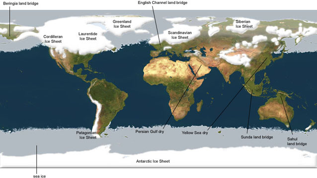
Figure 1: Global ice cover during the Last Glacial Maximum (~20,000 years ago)
(Source: The Last Ice Age, Map)
During the Last Glaciation, two major ice sheets formed and covered most of northern North America (Fig. 2). The Laurentide Ice Sheet (LIS) formed east of the Rocky Mountains, attained a thickness that exceeded 3000 m, and covered almost all of central and eastern portion of Canada and the northerly regions of the Great Plains, Midwest and Northeastern United States. The Cordilleran Ice Sheet formed as alpine glacial systems in the Coast Ranges and Rocky Mountains expanded and coalesced to cover almost all of British Columbia and the northern portions of Washington, Idaho and western Montana at its maximum extent (Figs. 2A and 2B).
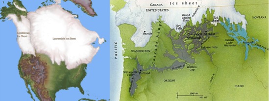
Figures 2A and 2B: Extent of the Laurentide and Cordilleran Ice Sheets during the Last Glacial Maximum (LGM) (Fig. 2A). The southern margin of the Cordilleran Ice Sheet covered the northern portions of Washington, Idaho and western Montana (Fig. 2B). Glacial Lake Missoula (turquois color) and the area inundated by the outburst floodwaters (gray color) is shown on Fig. 2B.
(Source: Glacial Maximum, Map) (Source: Parfit, The Floods that Carved the West, Map)
Following retreat of the Cordilleran Ice Sheet, glacial erratics were deposited over the landscape leaving a record of the Last Glacial period.
< Page 1 – Page 2>